


[EN] Road To TCR #16
THE DOT-SPLIT
My newsletter is now free!
At the moment, it's a bit of a challenge to find the time to deliver weekly content and still maintain the quality I aim for. So I've decided to make the newsletter available to everyone, with a slightly more spread out release schedule.
These letters will reflect my preparation, my experiences and what I learn as I go through the upcoming adventures. You can continue to help fund these projects exclusively: all donations and proceeds go directly into the account of my association, "Double Dash Spirit", which is exclusively dedicated to covering the budget for my next seasons.
This newsletter will also continue to evolve and provide more content. My aim remains to share my experiences and insights, whether to inspire you in your own practice, give advice on how to approach an event, or simply to keep you up to date with my future projects.
Thank you for your support on this journey!
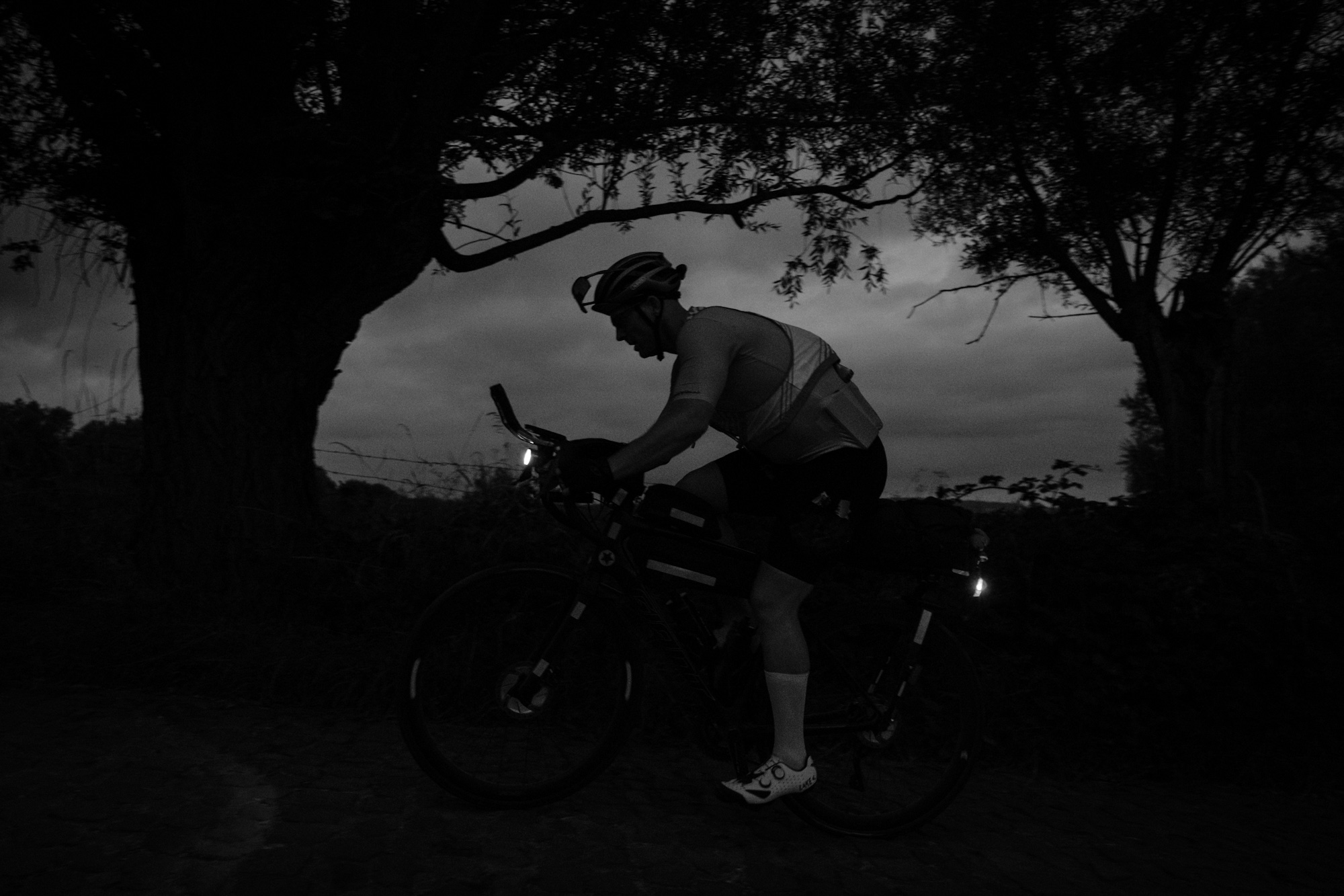
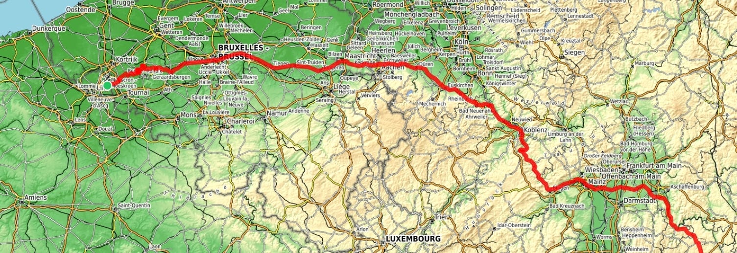
After starting the Transcontinental full of positive energy and finishing the first parcours with the iconic torchlight ascent of Muur Kapelmuur, a major split appeared among the riders. While a group led by Robin Gemperle took the northern route through Belgium, the Netherlands and northern Germany, others, like Christoph Strasser and myself, chose to follow the French border, crossing Luxembourg before entering Germany.
Today, we're going to examine the reasons behind this split in order to gain valuable insights into route planning and to determine the most strategic choices.
Race context
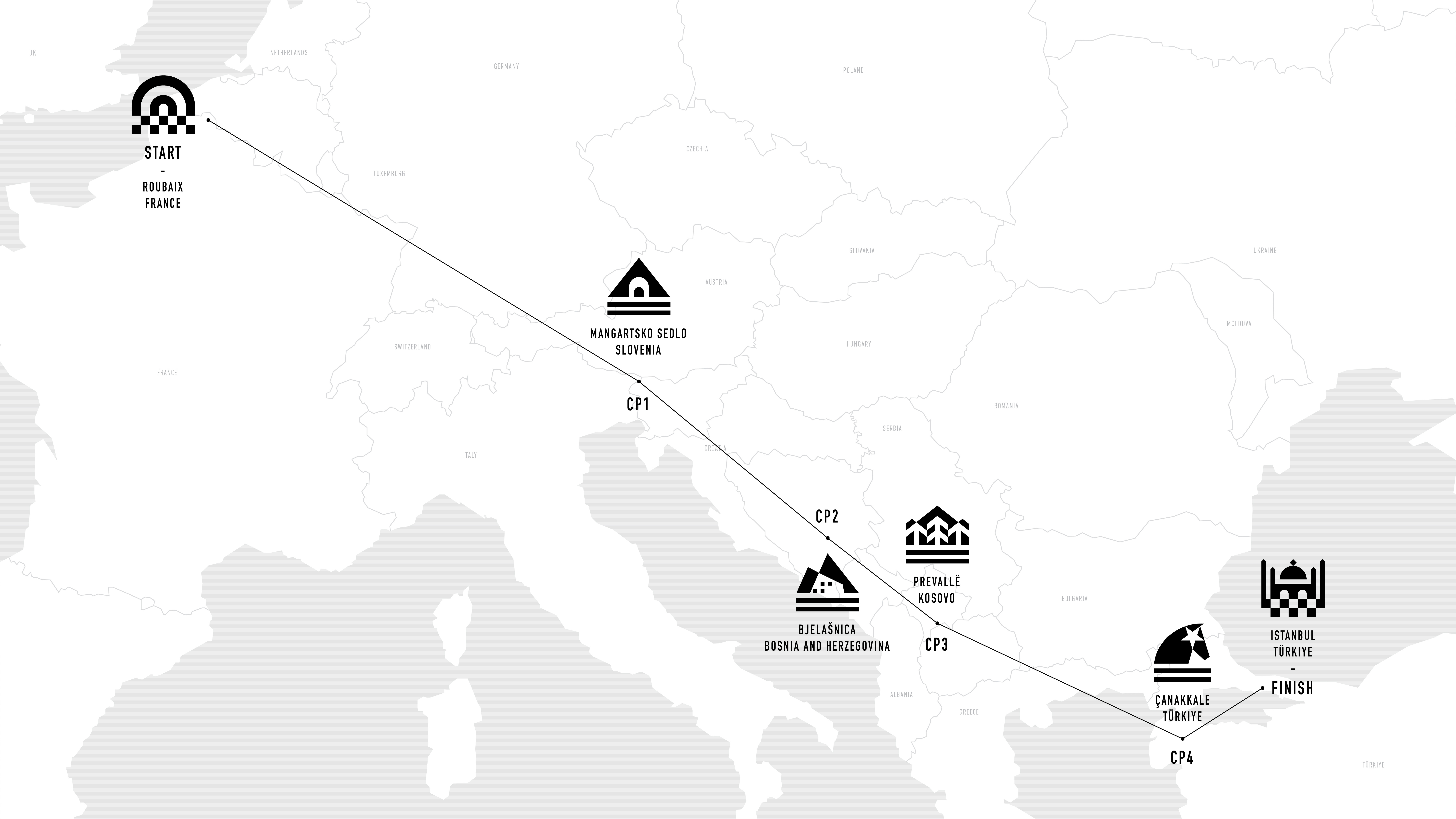
Firstly, a reminder of the basics: the TCR is a free-route race between several mandatory checkpoints. Around these checkpoints, we have to follow a "mandatory" parcours, from point A to point B, provided by the organisers, which we then combine with our own chosen routes. The choice of route is therefore key to both performance and strategy, as it allows us to save valuable time by choosing the most optimal route among many variables.
Let's take the Start-CP1 section as an example and look at the variables involved and the three main routes taken by riders:
Northern route, then east through the Alps (chosen by Robin Gemperle)
Southern route, then east through the Alps (my choice)
Southern route, via Innsbruck (chosen by Jana Kesenheimer)
Analyse des parcours et des variables stratégiques
1. Elevation gain
Robin clearly understood that the key to maximising speed was to minimise elevation gain (cf. analyse de la TCR No9). This was a key factor in his route planning.
Looking at the topographical map, it's clear that Robin wanted to keep the altitude as low as possible by following valleys and roads such as the one along the Rhine to Mainz. For the section from the end of the start parcours to Mainz, he covered only 1800 meters of elevation over 413 km, a relatively low total that helped him maintain a high, steady speed and conserve energy. In comparison, after 430 km, I had accumulated around 3100 meters of elevation.
For the Alpine crossing, Robin, like 90% of the top 10, chose the route through Salzburg, Obertauern, and Katschberg, with climbs under 10 km. I, on the other hand, opted for the Grossglockner, which was the closest route from Munich, although more demanding in elevation. This choice raised some doubts, but other riders, including Mikko Kainu (10th overall), eventually followed me.
Jana Kesenheimer, who finished first in the women's classification, opted for the shortest route, even though it was more challenging, taking in the Ardennes, the Black Forest and the Austrian Alps. Ultimately, these choices left Robin finishing the Start-CP1 section with 9500 metres of climbing, compared to my 10,800 metres and Jana's 12,200 metres.
2. Distance

If you draw a straight line from the end of the start course to the beginning of course 1, Jana's route appears to be the shortest, followed by mine and then Robin's. However, although his route is about 20 kilometres longer (1238 km versus 1213 km for Jana and 1212 km for me), Robin made up for this by reducing the elevation gain, which gave him a smoother route with fewer twists and turns (such as winding mountain passes) and helped him maintain a strong speed.
In some sections, I chose faster roads, even if it meant dealing with traffic, to avoid changing direction and save time. Jana, on the other hand, followed more cycle paths, which involve frequent crossings and a higher risk of navigational error.
On this particular section, for example, I saved 3km on Jana's route (shown in green) in just 20km:

3. Finding the right balance
But remember, speed isn't everything when it comes to choosing routes. Finding a mental balance and choosing routes that suit your riding style is key to maintaining good energy levels and achieving your best speed.
Think about what works best for you and what you enjoy along the way. Do you prefer cycle paths away from traffic, climbs under 10km, or perhaps a ride through towns and cities to take in the sights? Personally, I like routes where I can keep a steady and fast pace, avoid big cities and enjoy mountain scenery, but also have some flat sections. I plan my routes with these factors in mind to make the most of the experience and enjoy every moment to the full.
Reflecting on your goals before setting out is also essential: Are you here for the race or the journey, and in what balance? For me, it was first and foremost the race, but I still naturally tended towards routes that appealed to me, like crossing the Ardennes or tackling the Grossglockner. Similarly, when I lost my passport, I chose a loop route rather than an out-and-back route because it was easier for me mentally.
Managing mental strain is one of the most important aspects of long-distance riding. It’s what lets you push farther, even after a long day. Instead of stopping at 350 km, you might even make it to 400.
4. Other variables to consider
There are other factors to consider when planning a route, which may be specific to the area, such as river crossings like the Rhine that we encountered this year. It can be helpful to list these and check ahead, as some bridges or crossings don’t always allow cyclists.
Wind can also be an important factor. Checking regional wind patterns or using sites like Windy or Windfinder can help you avoid unpleasant surprises in headwinds or, alternatively, help you make the most of tailwinds. After all, cycling is a bit like sailing!
Road conditions are another key aspect. A route might seem to save you a few hundred meters, but if it’s in poor condition or gravel, it may not actually be faster! Rolling resistance is essential, not only for speed but also to avoid issues like punctures. It's not always worth the risk, so it's a good idea to do a bit of reconnaissance using Google Street View or Satellite View.
Finally, try to avoid large cities. This will help you avoid traffic, stoplights, and intersections that break your flow. But don’t swing too far the other way, try to stay close enough to civilisation and shops to avoid running out of food, water or nearby repairs in case of mechanical trouble.
Who was the fastest?
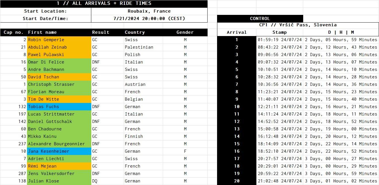
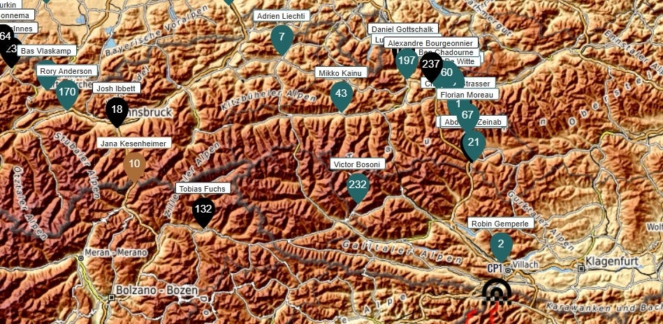
Observing the top 10 at CP1, the fastest riders all took the first option, with 100% of the podium following Route 1.
The first finisher on the second route, Omar di Felice, arrived in 4th place, seven hours behind Robin, while Tobias Fuchs, the first to finish on the third route, came in 10th, ten hours behind.
We can conclude that the first route was the fastest, thanks to its lower elevation gain and fairly direct roads, which allowed riders to fully benefit from a strong tailwind that day. This combination of factors allowed them to reach the checkpoint at the Vršič Pass in Slovenia ahead of the others.
There are plenty more factors that can shape your route to optimize speed and performance. Feel free to share any of your own tips in the comments, it would be great to learn from your insights and keep improving.
Thank you for joining me on this journey, and see you soon!
Victor